Our earth is undergoing many changes
These deformations are caused by the movements generated by various factors which are not completely understood and include the following:
1. The heat generated by the radioactive elements in earth’s interior.
2. Movement of the crustal plates due to tectogenesis.
3. Forces generated by rotation of the earth.
4. Climatic factors
5. Isostacy—according to this concepts, blocks of the earth’s crust, because of variations in density would rise to different levels and appear on the surface as mountains, plateaux, plains or ocean basins.

Endogenetic Movements:
The interaction of matter and temperature generates these forces or movements inside the earth’s crust. The earth movements are mainly of two types: diastrophism and the sudden movements.
1. Diastrophism:
It is the general term applied to slow bending, folding, warping and fracturing.
Such forces may be further divided as follows:
(i) Epeirogenic or continent forming movements act along the radius of the earth; therefore, they are also called radial movements. Their direction may be towards (subsidence) or away (uplift) from the centre. The results of such movements may be clearly defined in the relief.
Raised beaches, elevated wave-cut terraces, sea caves and fossiliferous beds above sea level are evidences of uplift. One of the reasons for believing that the Deccan was uplifted is that the nummulitic limestones rest uncomfortably on the basaltic lavas near Surat well above sea level.
Raised beaches, some of them elevated as much as 15 m to 30 m above the present sea level, occur at several places along the Kathiawar, Orissa, Nellore, Madras, Madurai and Thirunelveli coasts. Several places which were on the sea some centuries ago are now a few miles inland. For example, Coringa near the mouth of the Godavari, Kaveripattinam in the Kaveri delta and Korkai on the coast of Thirunelveli, were all flourishing sea ports about 1,000 to 2,000 years ago.
Evidence of marine fossils above sea level in parts of Britain and Norway is another example of Epeirogenic uplift.
Submerged forests and valleys as well as buildings are evidences of subsidence. In 1819, a part of the Rann of Kachchh was submerged as a result of an earthquake. Presence of peat and lignite beds below the sea level in Thirunelveli and the Sunderbans is an example of subsidence. The Andamans and Nicobars have been isolated from the Arakan coast by submergence of the intervening land. On the east side of Bombay Island, trees have been found embedded in mud about 4 m below low water mark.
A similar submerged forest has also been noticed on the Thirunelveli coast in Tamil Nadu. A large part of the Gulf of Mannar and Palk Strait is very shallow and has been submerged in geologically recent times. A part of the former town of Mahabalipuram near Chennai (Madras) is submerged in the sea. (Fig. 1.11)

(ii) Orogenic:
Orogenic or the mountain-forming movements act tangentially to the earth surface, as in plate tectonics. Tensions produces fissures (since this type of force acts away from a point in two directions) and compression produces folds (because this type of force acts towards a point from two or more directions). In the landforms so produced, the structurally identifiable units are difficult to recognise.
In general, diastrophic forces which have uplifted lands have predominated over forces which have lowered them.


2. Sudden Movements:
These movements cause considerable deformation over a short spans of time, and may be of two types:
(i) Earthquake:
It occurs when the surplus accumulated stress in rocks in the earth’s interior is relieved through the weak zones over the earth’s surface in form of kinetic energy of wave motion causing vibrations (at times devastating) on the earth’s surface. Such movements may result in uplift in coastal areas.
Another earthquake in Chile (1822) caused a one-metre uplift in coastal areas. Another earthquake in New Zealand (1885) caused an uplift of upto 3 metres in some areas while some areas in Japan (1891) subsided by 6 metres after an earthquake.
Earthquakes may cause change in contours, change in river courses, ‘tsunamis’ (seismic waves created in sea by an earthquake, as they are called in Japan) which may cause shoreline changes, spectacular glacial surges (as in Alaska), landslides, soil creeps, mass wasting etc. (Fig. 1.17)

(ii) Volcanoes a volcano is formed when the molten magma in the earth’s interior escapes through the crust by vents and fissures in the crust, accompanied by steam, gases (hydrogen sulphide, sulphur dioxide, hydrogen chloride, carbon dioxide etc.) and pyroclastic material. Depending on chemical composition and viscosity of the lava, a volcano may take various forms.
(a) Conical or Central Type:
When cooled lava particles from successive volcanic eruptions form a cone around the vent, a conical mountain shape emerges. This is a central type of volcano. Examples: Fujiyama (Japan) and Mount Vesuvius (Italy). The magma in such volcanoes is viscous, acidic and silicate.

(b) Shield Type:
The less viscous, less acidic and less silicate magma flows out slowly and quietly and gives rise to a wide-based plateau like formation with a gentle slope. Thus, a ‘shield shaped’ volcano with thin horizontal sheets emerges. Example: Mauna Loa (Hawaii).

(c) Fissure Type:
Sometimes, a very thin magma escapes through cracks and fissures in the earth’s surface and flows after intervals for a long time, spreading over a vast area, finally producing a layered, undulating, flat surface. Example: Deccan traps (peninsular India)

(d) Caldera Lake:
After the eruption of magma has ceased, the crater frequently turns into a lake at a later time. This lake is called a ‘caldera’. Examples: Lonar in Maharashtra and Krakatao in Indonesia.
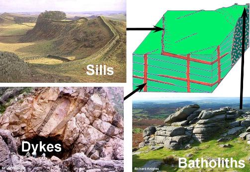
Volcanic Landforms:
The intrusive activity of volcanoes gives rise to various forms.

The intrusive activity of volcanoes gives rise to various forms.
Batholiths:
These are large rock masses formed due to cooling down and solidification of hot magma inside the earth. Batholiths form the core of huge mountains and may be exposed on surface after erosion.
Laccoliths:
These are basically intrusive counterparts of an exposed domelike batholith.
Dykes:
These are solidified vertical lava layers inside the earth.
Sills:
These are solidified horizontal lava layers inside the earth.
April 2015 Nepal earthquake
 
Kathmandu
| |
| Date | 25 April 2015 |
|---|---|
| Origin time | 11:56:25 NST[1] |
| Magnitude | 7.8 (Mw)[1] |
| Depth | 8.2 km (5.1 mi)[1] |
| Epicenter | 28.230°N 84.731°ECoordinates: 28.230°N 84.731°E[1] |
| Type | Thrust[1] |
| Areas affected | |
| Total damage | $10 billion (about 50% of Nepal's nominal GDP)[2] |
| Max. intensity | VIII (Severe)[1] |
| Aftershocks | 7.3 Mw on 12 May at 12:50[3] 6.7 Mw on 26 April at 12:54[4] 459 aftershocks of 4 Mw and above as of 24 May 2016[5] |
| Casualties | 3.5 million homeless[6] |

The April 2015 Nepal earthquake (also known as the Gorkha earthquake) killed nearly 9,000 people and injured nearly 22,000. It occurred at on 25 April, with a magnitude of 7.8Mw or 8.1Msand a maximum Mercalli Intensity of VIII (Severe). Its epicenter was east of Gorkha District at Barpak, Gorkha, and its hypocenter was at a depth of approximately 8.2 km (5.1 mi). It was the worst natural disaster to strike Nepal since the 1934 Nepal–Bihar earthquake. The ground motion recorded in Kathmandu valley was of low frequency which, along with its occurrence at an hour where many people in rural areas were working outdoors, decreased the loss of property and human life.
The earthquake triggered an avalanche on Mount Everest, killing 21, making April 25, 2015 the deadliest day on the mountain in history. The earthquake triggered another huge avalanche in the Langtang valley, where 250 people were reported missing.
Hundreds of thousands of people were made homeless with entire villages flattened, across many districts of the country. Centuries-old buildings were destroyed at UNESCO World Heritage Sites in the Kathmandu Valley, including some at the Kathmandu Durbar Square, the Patan Durbar Square, the Bhaktapur Durbar Square, the Changu Narayan Temple, the Boudhanath stupa and the Swayambhunath Stupa. Geophysicists and other experts had warned for decades that Nepal was vulnerable to a deadly earthquake, particularly because of its geology, urbanization, and architecture.
Continued aftershocks occurred throughout Nepal at the intervals of 15–20 minutes, with one shock reaching a magnitude of 6.7 on 26 April at The country also had a continued risk of landslides.
A major aftershock occurred on 12 May 2015 at with a moment magnitude (Mw) of 7.3. The epicenter was near the Chinese border between the capital of Kathmandu and Mt. Everest. More than 200 people were killed and over 2,500 were injured by this aftershock and many homeless.
Top 10 Earthquake Prone-Areas in India
The Indian subcontinent has a history of devastating earthquakes. An earthquake of 7.2 magnitude struck Tajikistan and the tremors were felt in India and Pakistan.
The epicentre of the earthquake was Tajikistan, measuring 7.2 on the Richter Scale and was recorded at 25 km.India is very prone to earthquakes as well. The major reason for the high frequency and intensity of the earthquakes is that the Indian plate is driving into Asia at a rate of approximately 47 mm/year. As per the Geographical statistics, almost 54% of the land in India is vulnerable to earthquakes.
According to the estimates shown by a World Bank and United Nations report; around 200 million city dwellers in India will be exposed to storms and earthquakes by 2050.
The latest version of the seismic zoning map of India assigns four levels of seismicity for India in terms of zone factors, which means India is divided into 4 seismic zones:
Zone 2
Zone 3
Zone 4
Zone 5
Zone 5 is highly prone to the earthquake with the highest level of seismicity whereas Zone 2 is associated with the lowest level of seismicity. So, the Zones - marked two to five -indicate areas most likely to experience tremors with five being the most vulnerable.
Indian cities, ranging from the metros to the smaller cities - all at least once have been shaken up due to earthquakes which usually range from medium to high intensity on the Richter scale.
With some research we present you the top 10 Indian cities which are observed as high earthquake prone zones:
1. Guwahati - Assam
Guwahati falls in zone five of the seismic zones in India which is highly prone to earthquakes. The place has seen some of the deadliest earthquakes and even today small tremors are a common situation. Guwahati receives earthquake predictions on a daily basis; resulting which many adjoining areas in the North-East get affected.
2. Srinagar - Jammu and Kashmir
This capital city of Jammu and Kashmir also comes under Seismic Zone
Most parts of the Kashmir Valley, which is around 11% of the area of the state covering the Districts of Srinagar, Ganderbal, Baramulla, Kupwara, Bandipora, Budgam, Anantnag, Pulwama, Doda, Ramban, Kishtwar, come under Seismic Zone 5, where around 50% of the population of the state lives. The rest of the state, including the whole of the Ladakh region and Jammu Division (90% of the total area of the state), are under the Seismic Zone 4.Being very close to the Himalayas, Srinagar faces heavy risk of earthquakes, high as well as moderate. The friction between the Indian and the Eurasian plane causes earthquakes to occur on the areas close to the Himalayas.
3. Delhi
Delhi is categorised under Seismic Zone 4.
Delhi has been hit by five devastating earthquakes measuring higher than magnitude of 5 since 1720. The most prone to earthquake neighbourhoods in Delhi lie about two miles on either side of the Yamuna river, the southwestern outskirts of the city known as the Chhattarpur basin, as well as an area popularly known as The Ridge in Delhi
4. Mumbai - Maharashtra
Mumbai falls in the Zone 4 of the seismic zone divisions which makes it quite vulnerable to damage.
We all know Mumbai is located on the coastal line, which increases the risk of facing tsunami-like disasters. Mild to strong earthquakes are very common in parts of Mumbai. Mild earthquakes are often faced by people living there and parts of the adjoining regions of Gujarat. It should be noted that for the last 20 years, almost all of the buildings in Mumbai have been designed and built keeping in mind that the city falls in seismic zone 4
5. Chennai - Tamil Nadu
The city, formerly in the comfort Zone 2, has now shifted to Zone 3 - indicating higher seismic activity. According to the seismic mapping , districts in the western part along the border with Kerala are also in Zone 3, along with districts along the border of Andhra Pradesh and a section of the border with Karnataka.
The status of Chennai along with major towns on the eastern coast in terms of vulnerability has increased especially after Chennai experienced tremors in September 2001 following a quake measuring 5.6 on the Richter scale off the Pondicherry coast.
Tamil Nadu, had faced the wrath of the deadly 2004 tsunami when the Marina beach was affected.
Recently, in the year 2012, Chennai shook terribly due to a rather high intensity earthquake (having its epicentre in the Indian Ocean).
The other 5 cities in right order of chronology are:
6. Pune - Maharashtra
7. Kochi - Kerala
8. Kolkata - West Bengal
9. Thiruvananthapuram - Kerala
10. Patna - Bihar

10 Most Active Volcanoes In The World
Here’s a list of the Most Active Volcanoes in the World. The volcanoes below are considered especially dangerous due to latest eruptions or due to being included in the Decade Volcanoes list. The Decade Volcanoes list is a list of 16 volcanoes worldwide identified by the International Association of Volcanology and Chemistry of the Earth’s Interior (IAVCEI) as being worthy of particular study in light of their history of large, destructive eruptions and proximity to populated areas.
1. Eyjafjallajökull, Iceland – Icelandic for “Island mountain glacier”, this volcano is one of the smaller ice caps of Iceland. The ice cap covers the caldera of a volcano with a summit elevation of 1,666 meters (5,466 ft). The 2010 eruption caused enormous disruption to air travel across western and northern Europe. About 20 countries closed their airspace to commercial jet traffic and it affected more than 100,000 travelers
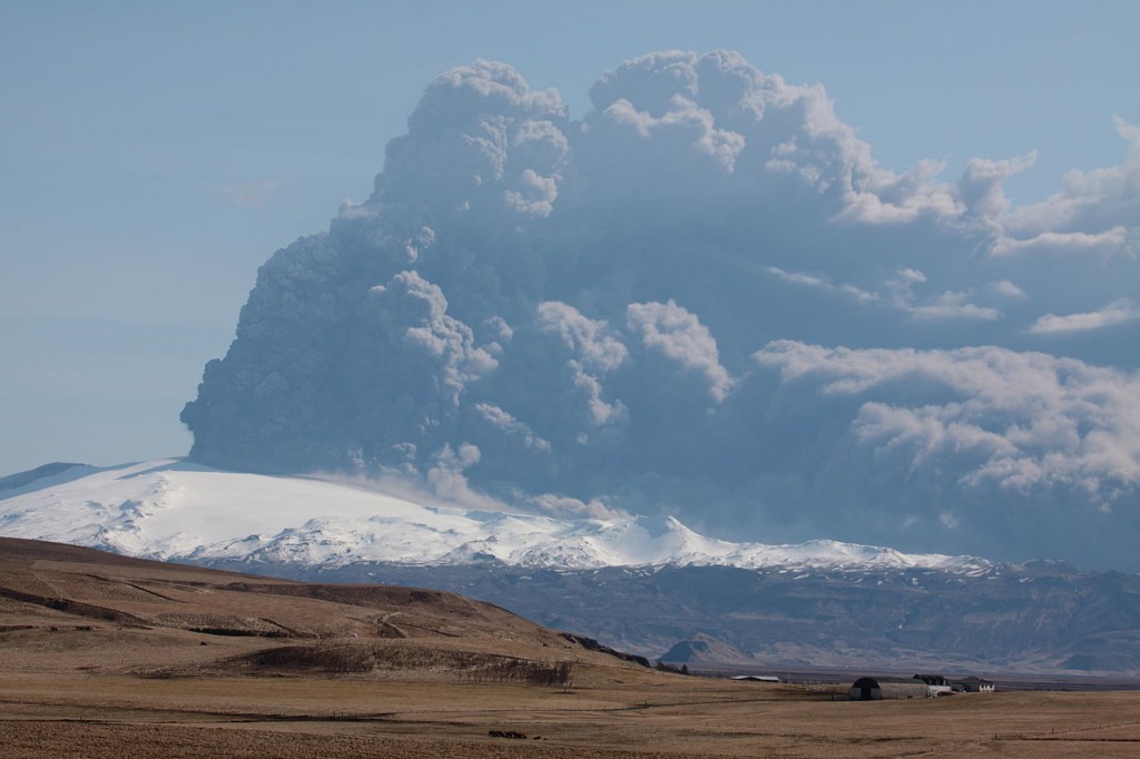
Eyjafjallajokull eruption of 2010. Hundreds of flights were cancelled
2. Mount Vesuvius, Italy – Located just 9 km (5.6 mi) east of Naples, making it the most densely populated volcanic region in the entire world. Mount Vesuvius has a history of activity that makes it one of the world’s most dangerous volcanoes. It last erupted was in 1944, but the most memorable eruption was the massive eruption of 79 AD, when it buried the cities of Herculaneum and Pompeii
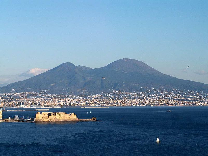
Buried the city of Pompeii in 79 AD – Mount Vesuvius
3. Sakurajima, Japan – An active volcano and a former island. The lava flows of the 1914 eruption caused the former island to be connected with the Osumi Peninsula. The volcanic activity still continues, dropping large amounts of volcanic ash on the surroundings. Earlier eruptions built the white sands highlands in the region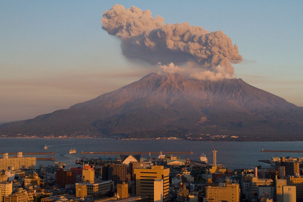
The lava connected the island to the mainland – Sakurajima
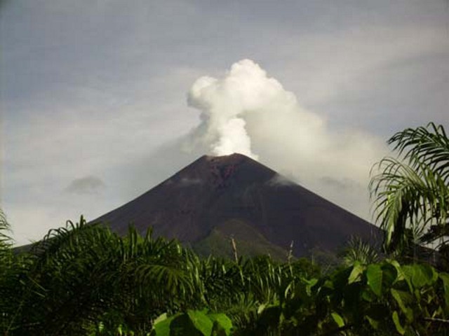
4. Mount Merapi, Indonesia – “Fire Mountain” is an active volcano located on the border between Central Java and Indonesia. It is the most active volcano in Indonesia and has erupted regularly since 1548. Thousands of people live on the flanks of the volcano
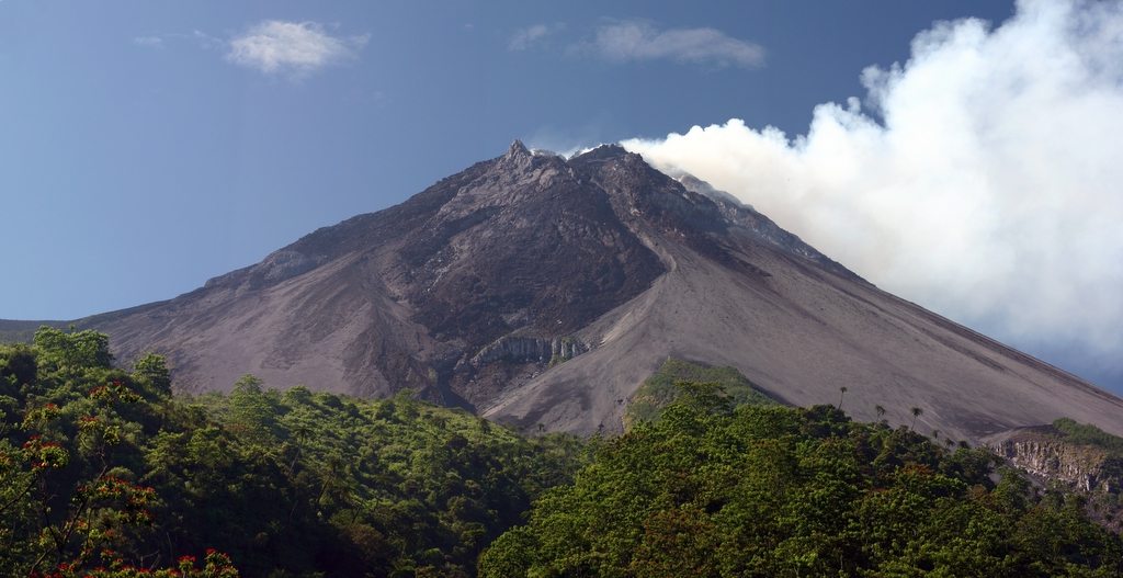
Mount Merapi
5. Mount Nyiragongo, D.R of Congo – An active volcano located inside Virunga National Park, in the Democratic Republic of the Congo. The main crater is about two km wide and usually contains a lava lake. Nyiragongo’s lava lake has at times been the most voluminous known lava lake in recent history. Nyiragongo and nearby Nyamuragira are together responsible for 40% of Africa’s historical volcanic eruptions
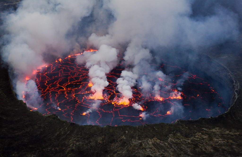
lava lake in Mount Nyiragongo, D.R of Congo
6. Ulawun, Papua New Guinea – Situated on the island of New Britainit, it is the highest mountain in the Bismarck Archipelago at 2,334 meters (7,657 ft), and one of the most active volcanoes in Papua New Guinea. Several thousand people live near the volcano. There have been 22 recorded eruptions since the 18th century
Mount Ulawun
7. Taal Volcano, Philippines – The second most active volcano in the Philippines with 33 historical eruptions. All of these eruptions are concentrated on Volcano Island, an island near the middle of Taal Lake. Taal Volcano and Lake presents one of the most picturesque and attractive views in the Philippines
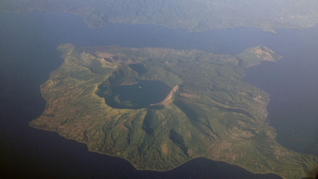
Taal Volcano
8. Mauna Loa, Hawaii – One of five volcanoes that form the Island of Hawaii and the largest on Earth in terms of volume and area covered. The Hawaiian name “Mauna Loa” means “Long Mountain”. Lava eruptions from Mauna Loa are very fluid; eruptions tend to be non-explosive and the volcano has relatively shallow slopes
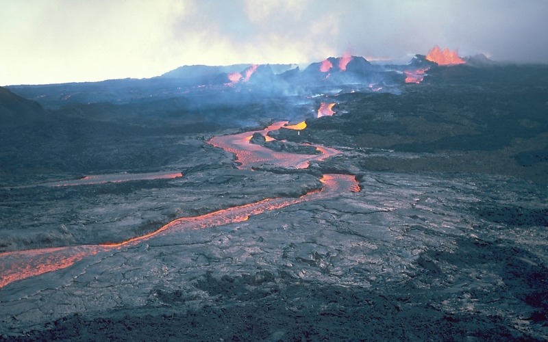
Mount Loa, Hawaii
9. Galeras, Colombia – It summit rises 4,276 meters (14,029 ft) above sea level. It has erupted frequently since the Spanish conquest, with its first historical eruption being recorded on December 7, 1580. A 1993 eruption killed nine people, including six scientists who had descended into the volcano’s crater to sample gases. It is currently the most active volcano in Colombia

Galeras, Colombia
10. Santa María, Guatemala – Its eruption in 1902 was one of the four largest eruptions of the 20th century and one of the five biggest eruptions of the past 200 years.
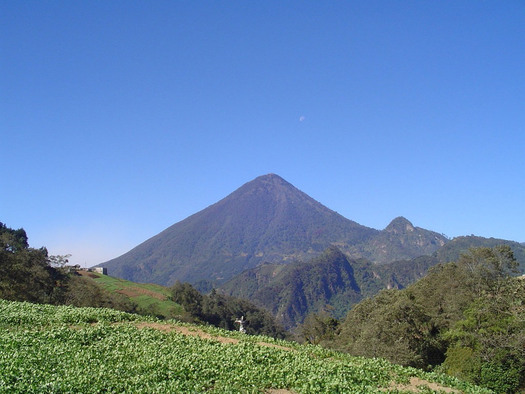
Santa Maria, Guatemala